
In Estonia, the Rail Baltica corridor in the three counties through which the railway passes was laid down in county plans.
– The planning process started a year later, in 2013, on the basis of the Government of the Republic’s order of 2012.
– The county governors of Harjumaa, Raplamaa and Pärnumaa adopted the Rail Baltica regional plans in 2016.
– The Minister of State Administration adopted the regional plans in February 2018.
The plans established a 350-metre-wide corridor for the railway and related infrastructure (service roads, access roads to land, overpasses and crossings, eco-ducts, etc.). The 350-metre corridor includes a displacement margin, while the actual land requirement for the railway is 66 metres. The “displacement needs” in relation to the axis of the corridor defined in the planning were defined during the preliminary design completed in October 2018.
In Harju and Rapla County, the last Rail Baltica planning public hearings took place in July-August 2016, in Pärnu County in November-December. In Harju County, 5 public consultations were held on the plans – in addition to the county-wide consultation, meetings were also held in Maardu, Rae, Kili and Saku. In Rapla, a county-wide consultation was also held, as well as consultations in Raikküla, Järvakandi, Kohila and Kehtna. In Pärnu County, 8 public consultations were held in January 2017.
In total, 86 public consultations were held as part of the planning and EIA process, with more than 4,000 participants!
See the route of the Estonian part of Rail Baltica in the GIS map application.
Definitions
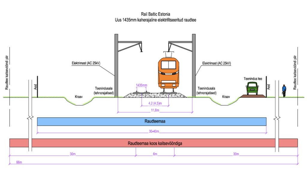
Line corridor – A railway line corridor is the land required for the construction of a railway line and the railway protection zone with the “displacement space” of the line. In a built-up area, the corridor is 350 m wide. In Tallinn, Pärnu and in larger populated areas where the corridor runs along an existing railway line (i.e. in a well-established built environment), the corridor width is 150 m.
Within the corridor is the proposed railway land with the protection zone, which is generally 66 m wide and is enclosed by a fence from an approximate distance of 35 m from the line.
‘Railway land ‘ means the land underneath the railway and railway infrastructure buildings and installations and the land needed to serve them (lines, embankments, maintenance tracks, noise barriers, etc.). The extent of the railway track including the protection zone is generally 66 m, but may be wider in the case of special railway facilities (stations, marshalling yards, sidings).
Set-back – (142 m in rural areas and 42 m in larger settlements) is necessary to allow for the necessary refinements in the design. It is not possible to take account of all the details required for planning purposes when drawing up the regional plans, due to the approach inherent in regional planning and the high degree of generality of the maps produced.
‘railway protection zone ‘ means an area of land intended to ensure the proper functioning of the railway and the uninterrupted movement of railway traffic and to reduce the harmful effects of the railway. The width of the protection zone is calculated at 30 m from the track axis (on multiple track lines and in stations from the extreme track axis) (as specified in the draft Railway Act). According to the current legislation, the width of the protection zone is 30 m in towns and settlements and 50 m outside towns and settlements.
Within the protection zone of the railway (outside the area enclosed by a fence), the construction of buildings and installations, the storage and installation of equipment and materials that jeopardise visibility within the protection zone may only be carried out with the prior written consent of the Technical Supervisory Authority and the relevant infrastructure manager or other owner or keeper of the railway.
